Storms are currently rolling through the Mid-South, bringing a good splurge or rain. With the weekend now here, it brings the question: “How wet is the weekend supposed to be?” We will break down those rain chances, talk about how long we remain dry next week, and even take a peak at early projections for our Christmas forecast.
Tonight and Tomorrow
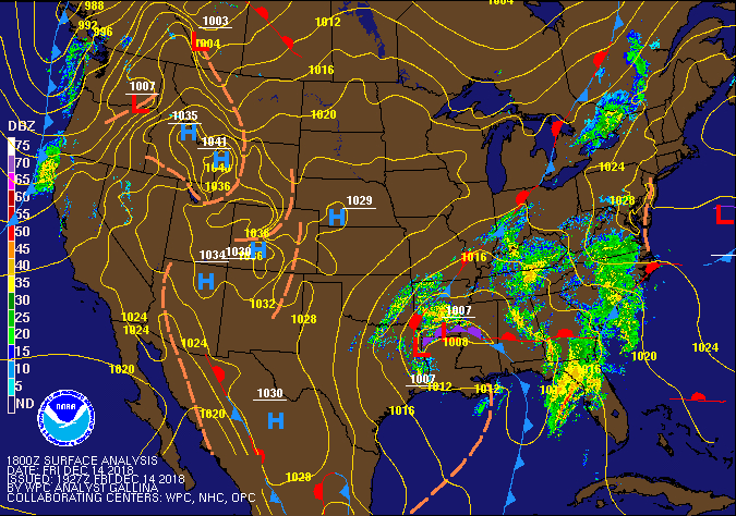 |
| National Weather Service’s surface analysis map, showing the low pressure system bringing rain for the Mid-South. |
Sunday-Wednesday
 |
| Weather Prediction Center’s QPF Totals showing that we aren’t expecting much rain over the next 5 days. |
Wednesday Night-Friday
Wednesday night brings the return of clouds and rain chances. A shortwave will drop from the north, meaning that we will have conditions, though minimal, for getting some shower activity going. With the rain comes cloud cover which should help insulate us and keeping our temps a little warmer overnight, with a low near the mid 40s.
 |
| A shortwave Wednesday night into Thursday in the Mid-South brings minimal rain chances that night and through the day. |
Rain chances from Wednesday night last into Thursday, though rain chances never climb too high. The weak shortwave mean that at most we will see scattered rain chances through the day as we remain mostly cloudy. Highs remain in the mid 50s. By that evening, we dry out somewhat as the clouds try to hang on. Lows in the lower 40s.
Friday takes on an interesting look for the forecast with a low pressure system setting up behind the shortwave. Depending on how fast and how far the low digs will determine how much moisture is pumped out of this system late Friday and into Saturday. Likewise, we need to watch how fast the cold air on the back side of the low infiltrates. For now, we are sticking with our normal forecast and saying mostly sunny skies for your Friday and temps climbing to the mid 50s. We will keep watching Friday night into Saturday as more model runs/data come available.

Christmas Outlook

With Christmas less than two weeks away (queues holiday panic), we are close enough to get some rough idea what that time frame will look like. At the moment, as per the Weather Prediction Center, it looks to be a good chance we keep an above average weather pattern for that time frame. For those that don’t like warm Christmases, we do have some good news so don’t freak yet. Looks like we will be remaining near average precipitation wise, so no major wash outs for Christmas foretasted at the moment. In fact, ensemble forecasts look like they place us in a ridge during that time frame, which would mean we remain dry. All this said, there is still plenty of time for this forecast to change. Likewise, you know where to go to in order to find those changes!

 |
| The WPC’s temperature and precipitation outlooks are showing near average precipitation and above average temperature probabilities for the week of Christmas. |
Reggie Roakes
MWN Meteorologist
—-
Follow MWN on Facebook and Twitter for routine updates and the latest info!
Complete MWN Forecast: MemphisWeather.net on the mobile web or via the MWN mobile app
Download our iPhone or Android apps, featuring StormWatch+ severe weather alerts!
 |
|
| MWN is a NOAA Weather Ready Nation Ambassador | Meteorologist Erik Proseus is an NWA Digital Seal Holder |