


Severe weather season in the Mid-South started in mid-March with three consecutive weekends interrupted by severe storms and tornado threats. But that was apparently just a multi-course appetizer leading up to the main course: a multi-day severe weather event over roughly 96 hours from April 2-5.
It started with a rare severe thunderstorm High Risk (level 5) day on Wednesday evening and culminated with another High Risk day – for excessive rainfall and flash flooding – on April 5 that was matched with a level 4 Moderate Risk of severe storms. In between, torrents of rainfall and rounds of severe storms soaked a nervous community that grew weary with each day’s updated severe weather outlook.
In this blog post, we take a look at the highlights of the events, including some very impressive statistics. Should additional information is released by the National Weather Service, particularly more results from storm surveys where tornadoes occurred, it will be added.
Wednesday, April 2
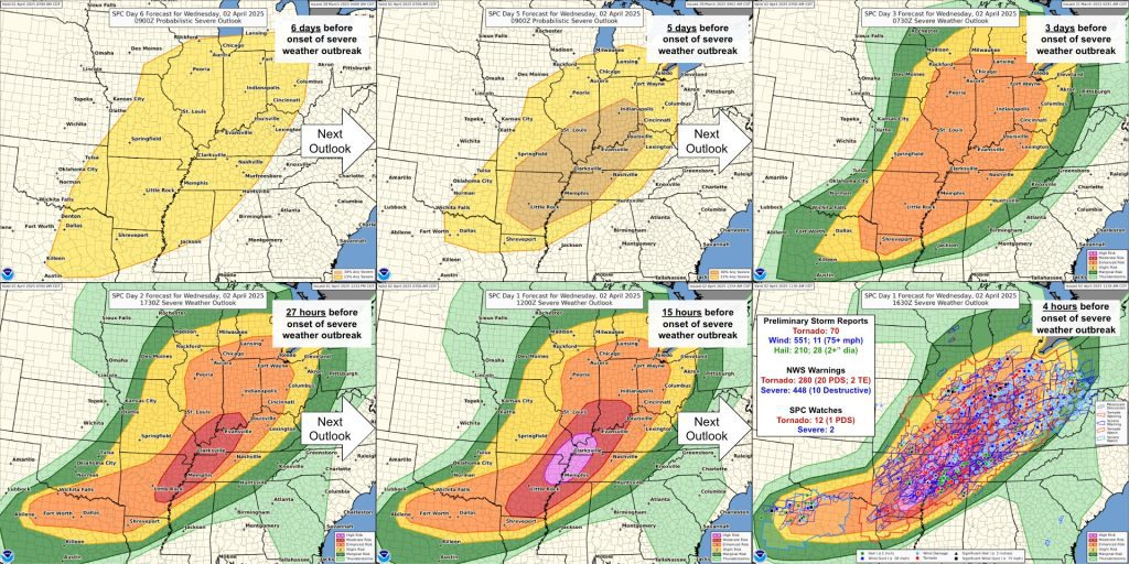
After a severe weather event on Sunday, March 31, all eyes were turning to Wednesday, which had been highlighted by the Storm Prediction as a potentially volatile days in advance,
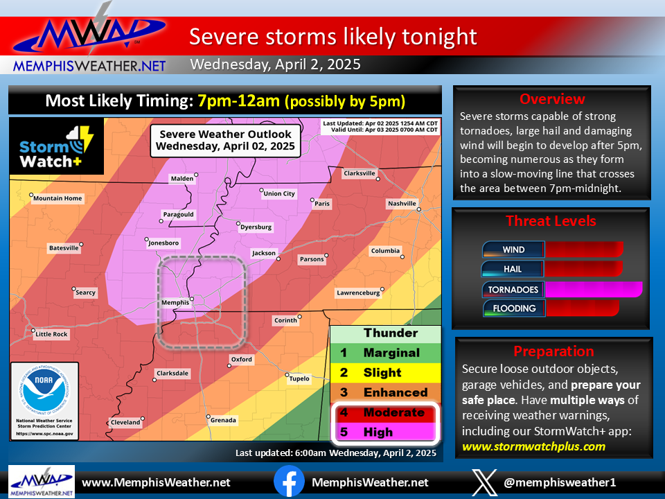
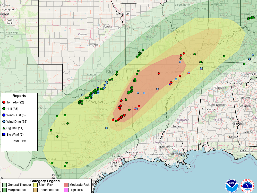
By Wednesday morning, a Level 5 High Risk was hoisted for the Memphis metro, the first in the NWS Memphis coverage area since the day of the Covington, TN tornado on March 31, 2023. While multiple tornadoes occurred that evening in the Mid-South, the immediate Memphis area was spared.

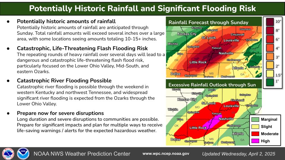
Also, on Wednesday, communication began on the potential for historic, even “generational,” flooding over the coming days, when very heavy rain would likely result in flash, urban, stream and river flooding.
Thursday, April 3 – Friday, April 4
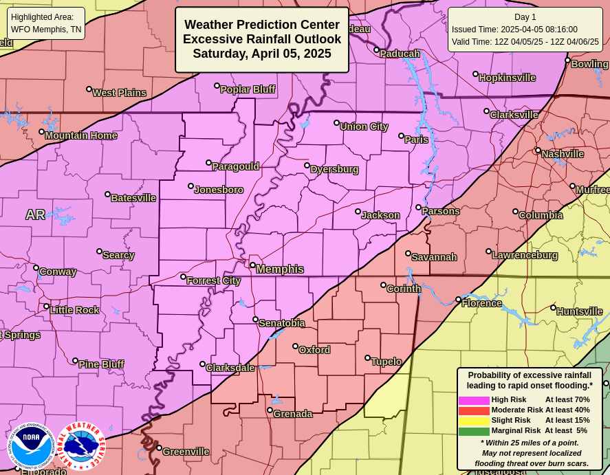
Heavy rain on Wednesday and again Thursday primed the pump for a significant flooding day on Saturday. First, the front responsible for the active weather pattern retreated into AR, shifting the heavy rain threat west. Another High Risk, this time for excessive rainfall that would lead to flooding, was posted for the Memphis metro.

Saturday, April 5
In addition to the flooding threat, the metro was also upgraded to a level 4 Moderate Risk severe weather zone by midday. A severe bow echo moved across the northern metro in the afternoon, which stabilized the lower atmosphere enough to force the threat of supercells east of the metro in northeast Mississippi wher multiple long-track tornadoes occurred.


Overall statistics
The National Weather Service in Memphis issued 262 warnings in all of 2024. In the first week of April 2025, 223 total warnings were issued, 85% of the total from all of 2024.
There were 32 tornado touchdowns on Wednesday, Thursday and Saturday within the NWS-Memphis service area. Summaries of all of them can be found here and the graphic below shows each of them on a map of the NWS-Memphis service area. (Subsequent to the map below being produced, three additional tornado tracks were identified, bringing the total to 35.)
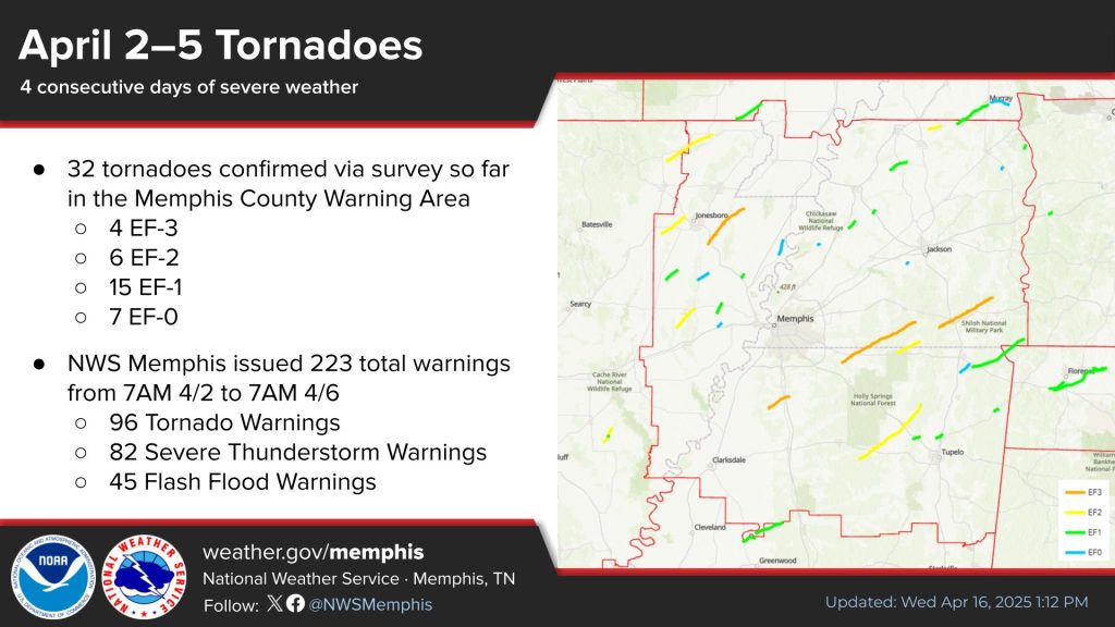
The chart below summarize the most significant tornadoes, as well as those that occurred within the 8-county MWN coverage area (bolded).
| Date / Time | Location | Path Length / Path Length | Comments |
| April 2, 6:26-6:55 pm | Lake City/Monette, AR | 24.79 mi / 160 mph (EF-3) | Max width 1500 yards, 8 injuries |
| April 2, 7:35-7:38 pm | Jeanette, AR (Crittenden Co.) | 3.06 mi / 85 mph (EF-0) | Brief tornado, 0 injuries |
| April 3, 12:24-12:39 am | Senatobia, MS (Tate Co.) | 12.22 mi / 165 mph (EF-3) | Max width 650 yards, 2 injuries |
| April 3, 12:34a-1.07 am | Selmer, TN | 29.33 mi / 160 mph (EF-3) | 5 fatalities, 14 injuries |
| April 3, 1:13-2:02 am | Slayden/Grand Junction, TN (Marshall/Fayette Co.) | 39.93 mi / 160 mph (EF-3) | Max width 1200 yards, 2 fatalities, 2 injuries |
The following precipitation records were set between April 2-5, and the following rivers rose into major flood stage status as a result:
- 5.47″ of rain on April 5 (daily record and wettest April day on record)
- 4.32″ of rain on April 3 (daily record and tied for 4th wettest April day on record)
- 12.37″ of rain from April 2-5 (4th wettest four-day stretch on record)
- 6.90″ of rain from April 2-3 (14th wettest two-day stretch on record)
- Major Flood Stage on the Loosahatchie River at Arlington
- 4th Highest Crest on record on the Wolf River at Germantown
- Mississippi River at Memphis cresting at 36.5 feet, which is minor flood stage
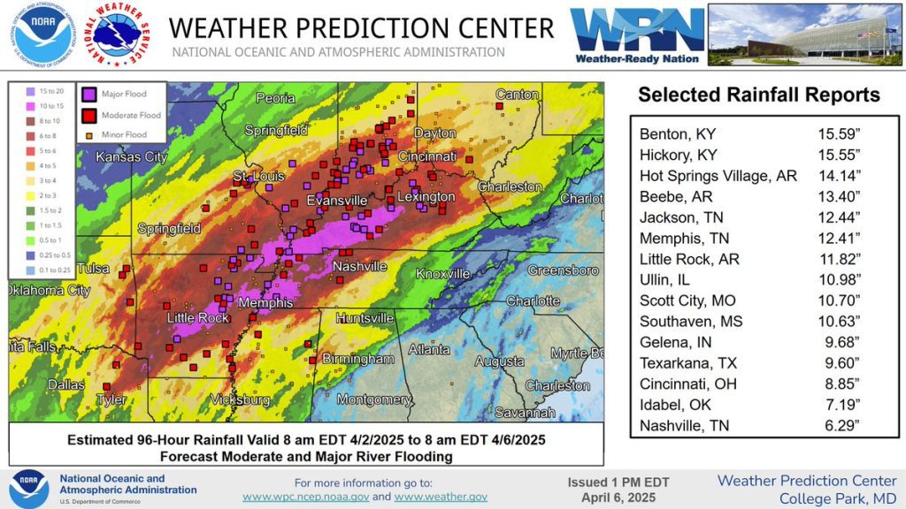
Overall, most rain gauges from central AR northeast across the Mid-South and into the lower Ohio Valley recorded 8-15″ or more rain over the four-day period. Rivers were in flood status throughout the region as a result of the multiple rounds of heavy rain and severe storms along and near the stalled frontal system, resulting in an historic sequence of weather events.
Acknowledgements
MemphisWeather,net wishes to express deep gratitude to National Weather Service-Memphis and all of their partners for the heroic work during this lengthy severe weather event and the days that followed. We are simply a conduit of their valuable information and timely and accurate weather warnings and are pleased to be able to provide this service to Memphis-area residents. Our condolences go to all Mid-Southerners who were affected in one way or another by the severe storms and resultant flooding.
Erik Proseus
MWN Meteorologist
—
Follow MWN on Facebook, Twitter/X, BlueSky, Threads and Instagram for the routine updates every day!
Visit MemphisWeather.net for the latest weather information and our MWN Forecast for Memphis and the Mid-South
Looking for a way to support us? Click here for one-time or recurring options! Thank you!







