

Thursday night
The first in a multiple round severe weather event will likely occur tonight as a cold front approaches the area, but remains to our northwest through Friday night. Upper level energy will encounter a very unstable airmass this evening, bringing the risk of a few strong to severe storms along the I-40 corridor and points north.
There is still a great deal of uncertainty, even just a few hours ahead of the potential event, as a strong “cap,” or lid on the atmosphere, could keep storms at bay, or at least limit their severity. If that cap gets overcome, threats include damaging wind gusts, some hail, and certainly dangerous lightning. The window opens after about 5-6pm tonight and chances continue according to some models, for much of the night. Again, still a lot of unknowns, so stay tuned to our social media feeds.
As of 2pm, a Severe Thunderstorm Watch has been issued for areas just northwest of the Memphis metro through 7pm. This does not preclude another watch later this afternoon that includes our area and goes later into the night.

Friday evening
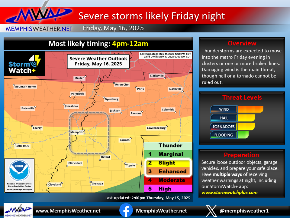
Once Thursday night’s storms move out early Friday morning, most of Friday during the day will be dry with very warm, humid air in place and wind gusts again to 25-30 mph. Then, another threat materializes Friday evening. This one will likely be more potent and certainly has higher potential to impact the metro. While the most severe storms capable of all hazards including tornadoes will be well to our north, a level 3 Enhanced Risk of severe weather extends south to include the northern sections of the metro, while a Slight Risk (level 2) includes the city of Memphis and northern MS.
Storms are expected to form to our west and move into the metro during the evening, possibly as early as 4-5pm, but likely by mid-evening. Storms may be organizing from clusters into broken line(s) as they move into the metro, bringing threat of large hail and damaging wind gusts, as well as a small chance of a tornado. Models do agree that this event is likely to be done by about midnight Friday night as of right now. Those with outdoor plans, including at one of two competing BBQ contests, need to pay close attention to the weather and be prepared to seek shelter in something other than a tent when storms threaten!
The Weekend
The good news is that Friday night’s storms should clear things up pretty well for Saturday, perhaps leading to a completely dry day. It will be hot with highs in the upper 80s, but there will also be less wind and ever so slightly lower humidity. At this time, it appears the front becomes active again early Sunday with scattered showers and thunderstorms possible on Sunday. Given it is still more than 72 hours out, timing and exact threats, if any, are still too early to forecast.
Erik Proseus
MWN Meteorologist
—
Follow MWN on Facebook, Twitter/X, BlueSky, Threads and Instagram for the routine updates every day!
Visit MemphisWeather.net for the latest weather information and our MWN Forecast for Memphis and the Mid-South
Looking for a way to support us? Click here for one-time or recurring options! Thank you!







