

Storms got surprisingly strong last night, producing widespread damaging wind gusts that likely topped 70 mph across a large portion of DeSoto County, with some scattered power outages into far southern Shelby Co, and additional wind damage reports across portions of north MS. A large section of DeSoto County lost power behind these storms, which also may have produced a brief tornado near Hernando where damages seems focused. Memphis International reported a wind gust to 56 mph on the north side of the storm.
Looking ahead, we have about one more day with a severe weather threat. The daytime hours today bring a pause to the stormy pattern as weak high pressure builds aloft. By this evening, that starts to change as a very active pattern to our west starts to shift east towards the Mid-South. This could result in a few showers and thunderstorms in the metro late this evening with another threat early Tuesday morning (pre-dawn). Either of those “rounds” could have a severe storm or two, but the right mix of atmospheric ingredients will not be present to support widespread severe weather.

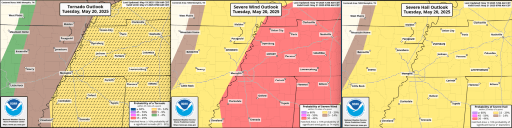
The “main event” is expected Tuesday afternoon as a cold front closes in, wind shear increases substantially and the atmosphere destabilizes by lunchtime. The approximate window for storms locally is between 2-6pm, though the actual threat period may only be an hour or two in that window. Afternoon storms are expected to form ahead of the cold front very near the Mississippi River and move east.

Storms will initially be supercellular in nature and scattered before forming more into a line of storm to our east. That means some of us won’t get any rain from the afternoon “round” of weather, while others nearby could receive damaging wind, hail and possibly a tornado. EVERYONE should prepare for the latter as there is no way to know where the storms will travel. Tornadoes that do form could easily be strong (EF-2+) and wind gusts could reach 70-80 mph.
By evening (at the latest), storms will be east of the metro, resulting in clearing skies and falling humidity Tuesday night and comfortable days Wednesday through Friday. A minor fly in the ointment, and reinforcing front, could result in a few showers Wednesday overnight, but generally mostly sunny skies and highs in the 70s with lows in the 50s are expected. By early Saturday, the upper level pattern begins to favor an increase in showers and thunderstorms under “northwest flow” – where storms to our northwest move southeast into the Mid-South – a notoriously problematic pattern to predict timing of precipitation.
Erik Proseus
MWN Meteorologist
—
Follow MWN on Facebook, Twitter/X, BlueSky, Threads and Instagram for the routine updates every day!
Visit MemphisWeather.net for the latest weather information and our MWN Forecast for Memphis and the Mid-South
Looking for a way to support us? Click here for one-time or recurring options! Thank you!







