

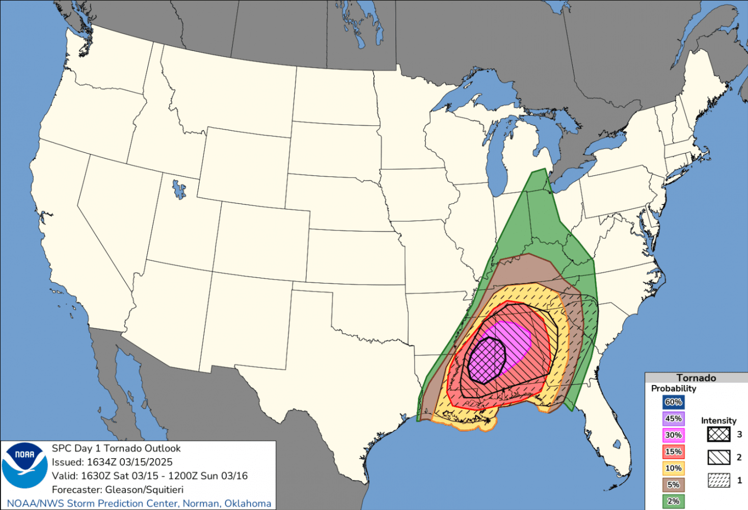
Since 2014, when Marginal and Enhanced risk levels were added to the old 3-point scale, NOAA’s Storm Prediction Center (SPC) has issued 5-level convective (thunderstorm) outlooks. When the forecasters at SPC identified a region with a 10% or greater risk of “significant severe” weather, a “hatched” area would overlay the outlook.
Starting on Tuesday, March 3, SPC is updating their convective outlooks with additional information to better identify days when especially violent or extreme weather is expected. Using recent upgrades in technology, advances in computer modeling, and better scientific understanding of the atmosphere, SPC will add more detail to their outlooks when significant storm potential exists.

Officially called “Conditional Intensity Groups,” or CIGs, this 3-level system will more widely be referred to as “Intensity Levels” and will help communicate increasing intensity of significant severe hazards posed by strong tornadoes, very large hail or extreme wind. The word conditional in the name implies that higher intensity storms are expected SHOULD severe weather occur. In other words, if severe weather occurs at your location, there is an elevated risk that it could be a higher end event.
The existing 5-level outlook scale – increasing from Marginal to Slight to Enhanced to Moderate to High Risk – will not change and is based on the probability of severe weather happening (technically within 25 miles of a forecast point). The previous “Significant Severe” designation will be replaced with CIG1, CIG2, and CIG3 levels and will indicate the potential intensity of the storms. The two scales are not directly correlated and provide a more complete range of information to consider when preparing for severe weather.
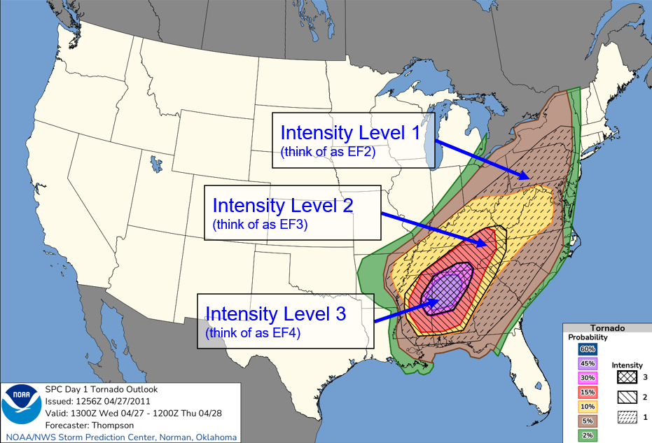
For example, consider a day where severe storms are expected to be isolated, but supercellular (meaning high-end tornado potential). While the convective outlook may show a Slight Risk (level 2) based on coverage of storms, a CIG1 may be included to indicate that any storms that form could have intense tornadoes. On the other hand, if widespread wind damage is expected, but not likely to be extreme (over 75 mph), an Enhanced Risk (level 3) may be issued based on expected coverage, but no CIG forecast would be necessary.
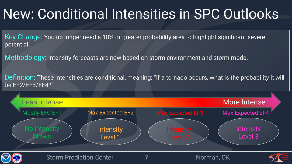
SPC outlooks will show the potential for the higher end intensities with hatching on their convective outlook graphics (see below). Intensity Level 1 (CIG1) will have dashed hatching from upper right to lower left. Intensity Level 2 will have solid hatching from upper left to lower right and indicates the potential for violent tornadoes from long-track supercell, bow echoes or derechos. Intensity Level 3 will be shown as solid cross-hatching and will be reserved for historic tornado outbreaks or high-end, ongoing derechos.

SPC has been experimenting with this process for five years outside of public view and they used 20 years worth of data to derive the bounds of the CIG levels, thereby demonstrating proven skill in discriminating between intensity levels. There is a lot of science behind this new methodology that is beyond the scope of this post. However, here are a few takeaways:
- There will be no changes to the 5 outlook categories that have been used for years. An Enhanced Risk in 2025 is the same as an Enhanced Risk in 2026. More emphasis will be placed on the colors/numbers over the category names, but the names will not change.
- Additional Intensity information will be displayed as 3 categories for tornado and wind and 2 for hail to aid in better communicating potential impacts. The default will be no CIG (a baseline severe weather event).
- Here at MemphisWeather.net, we rely on the experts at SPC to define the environment and its potential and will relay that information in as clear and concise a fashion as possible, so that you can be informed and prepared… not scared.
Have a question about the new intensity forecasts? Reach out on social media or comment below and we’ll do our best to give you a good answer! This is new to us as well and we’re interested to see how it works.
Erik Proseus
MWN Meteorologist
—
Follow MWN on Facebook, Twitter/X, BlueSky, Threads and Instagram for the routine updates every day!
Visit MemphisWeather.net for the latest weather information and our MWN Forecast for Memphis and the Mid-South
Looking for a way to support us? Click here for one-time or recurring options! Thank you!







