

More rain chances are returning to the Mid-South, and this time in the form of a remnant tropical cyclone. Barry is getting closer to the coast, and currently most models are in agreement that some remnants will be heading our way. This is good news for some, and bad news for others. While some areas and saying “bring it on,” others have had entirely too much water the past couple weeks. However, for everyone our regular afternoon thunderstorm chances are still sticking around to end your week and welcome in your weekend.

Earlier Today
We had a cold front move through this morning, and push into central MS. Now that it has stalled out, wind will momentarily be northerly overnight but clouds are going to clear out, bringing some decent conditions with temps dropping into the mid 70’s.
Friday
 |
| NAM-3km model precipitation from midday Thursday into the evening hours Friday. (Tropical Tidbits) |
The high-resolution NAM model is showing that cold front being pushed back north into the metro, bringing the threat of an afternoon shower or thunderstorm for Friday. Highest chances lookg to be in north MS, as areas north of Memphis look to be more stable. Most of the day we will see partly cloudy skies and continued highs in the lower 90’s with high humidity. Some cloud cover sticks around overnight and into Saturday with lows overnight dropping into the mid 70’s.
Saturday

Partly sunny skies to begin your Saturday, but increased chances of scattered showers and thunderstorms as Barry continues to push north. We’ll still feel those sultry conditions with highs in the lower 90’s despite the scattered showers and thunderstorms. Not too shabby for your Saturday, considering rain chances increase as we head deeper into the weekend.
Sunday

As we continue to wait in anticipation of the arrival of the remnants of Barry, we’re still seeing what’s left of the front that pushed back to our north. That’ll bring us more cloud cover, along with higher rain and thunderstorm chances. Highs are only expected to get into the mid-80’s however, so there is something to celebrate! Overnight temps will drop just a bit into the mid-70’s.
Beginning The Work Week
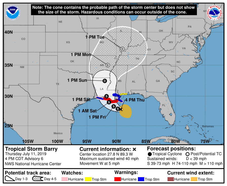 |
| Barry’s Predicted Path (NHC) |
Monday is when the chances of Barry moving through are becoming likely for the Mid-South. Although this track could still change a bit, the National Hurricane Center is beginning to get a better picture of what to expect. With this system heading towards us, we are looking at a good chance of showers and t’storms. On the bright side this will bring us some cooler weather, with highs only in the lower 80’s. By Tuesday, Barry should be pushing further north into the Ohio River Valley, leaving behind some scattered showers or thunderstorms. Temps will be nearing 90 again however, and by mid-week we will return to our typical Memphis summer weather.
 |
| The European model showing the entire path of Barry over the next week. (WxBell) |
An overall interesting week planned for the Mid-South, but we will begin to return to your average July weather in no time. Be sure to follow us for any updates to this system, and stay dry everyone!
Jennifer Lambers
MWN Meteorologist Intern
—-
Follow MWN on Facebook and Twitter for routine updates and the latest info!
Complete MWN Forecast: MemphisWeather.net on the mobile web or via the MWN mobile app
Download our iPhone or Android apps, featuring StormWatch+ severe weather alerts!
 |
 |
| MWN is a NOAA Weather Ready Nation Ambassador | Meteorologist Erik Proseus is an NWA Digital Seal Holder |







