Preliminary numbers are in and 2024 ended up warmer and wetter than average in Memphis. However, 2025 appears ready to reverse course, at least for the first couple of weeks!
Recapping a warm and wet year in Memphis
Last year the average temperature was just over 65 degrees in the Bluff City, as recorded at Memphis International Airport, which is 1.7 degrees above our annual average. The average high temperature was just above 74 degrees while the average low was around 56 degrees. As usual with Mid-South weather patterns though, there were huge swings in temperatures – from a couple of 100 degree days at the end of August to near zero in mid-January, resulting in a 98 degree difference between the hottest afternoon and coldest morning of the year!

(Data: National Oceanic and Atmospheric Administration)
Precipitation ended well above normal for the year (61.58 inches versus the average annual total of 55 inches), despite noteworthy drought conditions in early fall. As it turns out, if Memphis had not received over six inches of rain in the few days after Christmas, the year’s rainfall total would have ended right at average. Like temperatures, precipitation is cyclical, so dry patterns – such as the one that resulted in widespread drought in the early fall – are often offset by very wet periods like the past week.
Cold air will be the weather story to start 2025
As you have no doubt noticed, the 60s of late December have been replaced by much chillier air to start the new year. The arrival of more seasonal conditions is the first of what appears to be multiple shots of cold air that will envelope much of the central and eastern United States in the coming weeks. Long-range weather models are fairly unanimous in predicting well below normal temperatures, which will likely stick around at least into mid-January.
The magnitude of the cold air is less certain than its presence, but the middle of next week – at least as of now – could be the bottom of the temperature roller coaster here in the Mid-South. Temperatures may barely rise above freezing while low temperatures could drop into the teens. Combined with forecast northerly wind, wind chill values could be dangerously cold.
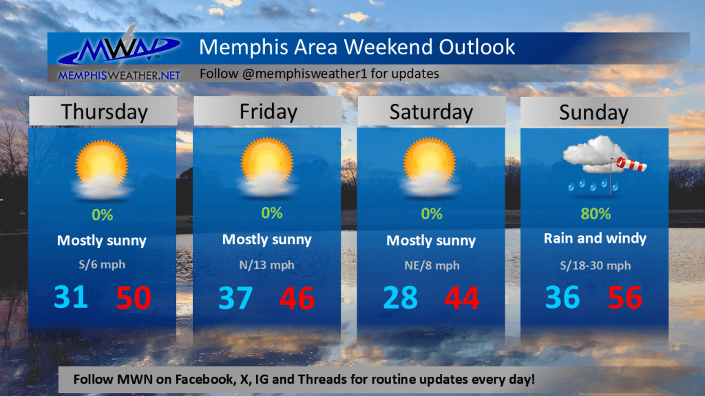
Cool, then wet, for the first weekend of the year
In the short term, temperatures will only be a little below early January averages to end this week and start the weekend, as dry conditions continue. By Sunday, a cold front that precedes the next big round of cold air will move into the Mid-South. Ahead of it, widespread precipitation is expected, mainly during the day Sunday into Sunday evening, totaling more than an inch of rain.
Breezy south wind will help keep temperatures well above freezing Sunday, resulting in rain and maybe even a few thunderstorms. It appears the chance of wintry precipitation should remain well to the north of the Memphis area.
Plan ahead for well below normal temperatures
Behind this system, temperatures drop rapidly as the next shot of Arctic air invades the region heading into next week. The next few days are a good time to prepare for the upcoming cold snap by protecting the 4 P’s – people, pets, plants, and pipes.
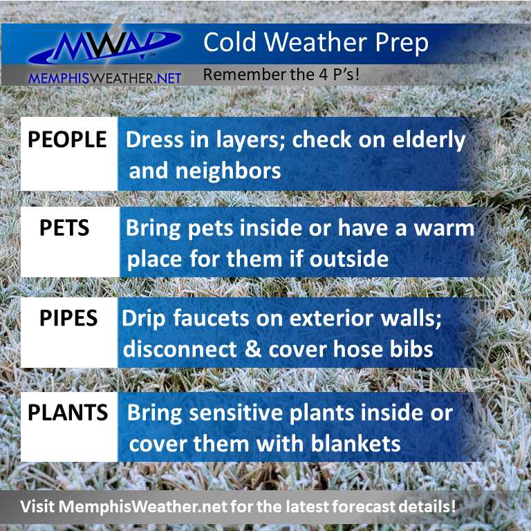
Ensure that those you care for and about (people and animals) have a warm place to stay, and that – when temperatures drop into the lower 20s or colder – you are dripping. For now, any precipitation during the cold air outbreak is expected to be minimal or too uncertain to mention at this point.
Erik Proseus
MWN Meteorologist
—
Follow MWN on Facebook, Twitter/X, BlueSky, Threads and Instagram for the routine updates every day!
Visit MemphisWeather.net for the latest weather information and our MWN Forecast for Memphis and the Mid-South
Looking for a way to support us? Click here for one-time or recurring options! Thank you!