


A roller coaster pattern last week that juxtaposed highs in the 40s one day with 70s the next, and so forth, finally settled down this week. But probably not where most of us wanted it to – cold and wet! A couple inches of rain have fallen so far this week and temperatures in the 30s and 40s haven’t made it feel any better.

Thankfully, we have some sunshine on deck the next couple of days to help lift the spirits of those who might be suffering from Seasonal Affective Disorder! It will still be cold, especially Thursday when highs will be near 40, but Friday looks pleasant after a cold start with highs eclipsing 50.
Spring-like setup means potential for strong storms
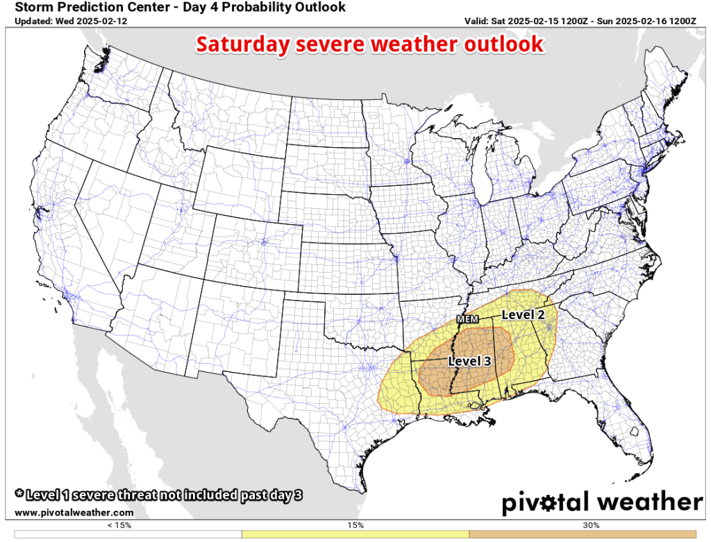
Looking ahead, the battle of the seasons returns with two potentially impactful storm systems in the extended forecast. On Saturday, warm Gulf air with unseasonably high moisture content joins up with a passing low pressure system and strong wind energy.
In the spring – which Saturday will mimic – that means a potential for severe thunderstorms. While the best chances will be south of I-40, and more likely south of the metro in MS and LA, a squall line of strong storms could affect the area in the late afternoon timeframe. Strong wind gusts will be the primary severe weather threat, though a couple tornadoes may be possible as well. Currently the metro is in the equivalent of a Level 2 severe weather risk, with a Level 3 equivalent extending into north MS. The forecast bears monitoring the next couple days.
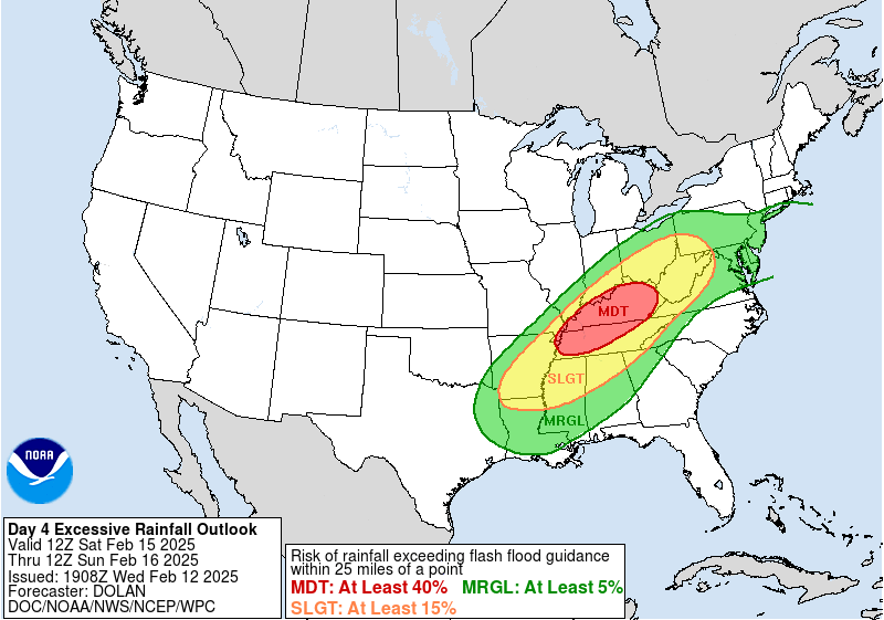
The more likely threat for our area Saturday will be heavy rain, which starts in the pre-dawn hours and could continue most of the day. Given the saturated ground leading up to this storm system, and the potential for multiple inches of rain, flash and river flooding are concerns. A Slight to Moderate Risk (Level 2-3 of 4) of heavy rain capable of flash flooding is currently forecast for the region.
Once Saturday’s system departs in the evening, dry and cool weather is forecast through early next week. Then things might get interesting again… This time a winter system, not a spring one, becomes a possibility.
Mid-week winter weather potential
While it is still a week out, we’ll be closely monitoring the forecast for next Wednesday and Thursday (Feb. 19-20) as another low pressure system moves through the southeast U.S. With cold air in place, there is indeed some potential for a winter weather event.
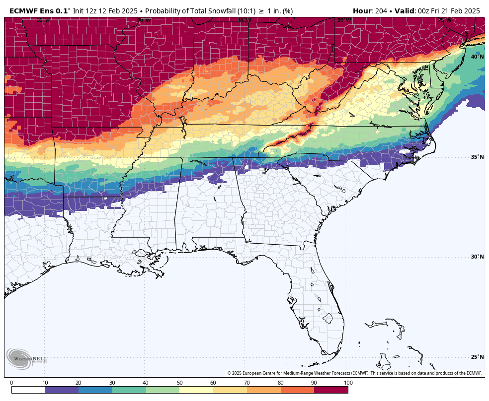
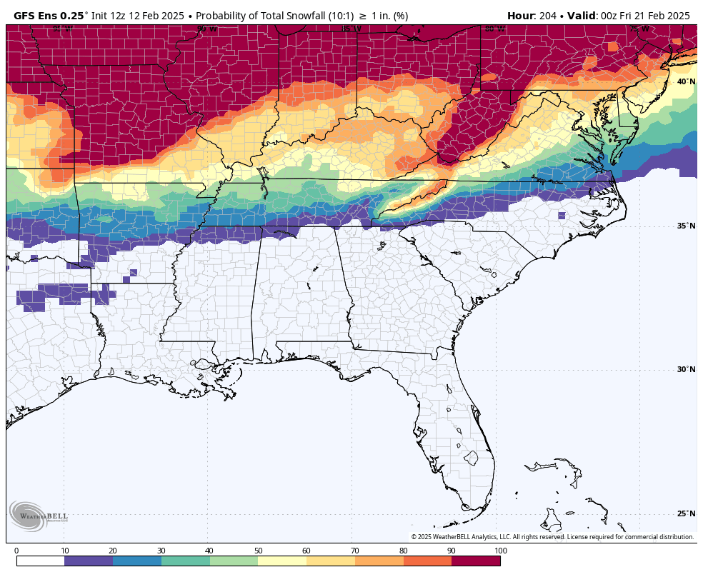
Many of you have asked about the forecast you have been seeing on your phones and social media – some showing up to 20 inches of snow. In a nutshell, that’s hogwash. Responsible meteorologists (and apps) won’t even provide snow totals that far out (and I’m not starting tonight). However, we can use our longer range data to provide some probabilities of what MAY be possible, but that is the extent of it. So for tonight… “there’s a chance” of winter weather the middle of next week.

Below you will see the probabilities of 1″ of snow through next Thursday from the European and American model ensembles. Ensemble data essentially runs through dozens of atmospheric scenarios and try to outline the potential, not the forecast. You’ll see that each thinks “there’s a chance” of minor accumulating snow. And if you have followed MWN very long, you already know my next statement – stay in touch and, as always, we’ll provide more concrete information as we get closer!
Erik Proseus
MWN Meteorologist
—
Follow MWN on Facebook, Twitter/X, BlueSky, Threads and Instagram for the routine updates every day!
Visit MemphisWeather.net for the latest weather information and our MWN Forecast for Memphis and the Mid-South
Looking for a way to support us? Click here for one-time or recurring options! Thank you!








Thank you always being the voice of reason! Been seeing some crazy forecasts, but you have taught us well to watch & wait! 😁
Good blog as always; nice to see a no-hype forecast on the internet every now and then!