

As cold raindrops started to fall Saturday morning, a few folks in the area reported seeing some frozen precipitation bounce on the pavement. As occasionally occurs when rain falls through a subfreezing and initially dry column of air, some raindrops freeze, resulting in sleet, even if surface temperatures are in the low 40s. As the calendar turns to December and with another round of precipitation arriving with slightly colder temperatures, are we in for more “winter shenanigans?”
Precipitation Type 101
First, we’ll start with a primer on winter weather precipitation types, as it may come in handy not just tomorrow, but perhaps several times this winter.
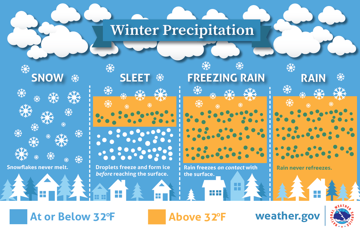
Temperatures at the ground level are only one factor in what type of precipitation we receive. Perhaps more importantly, the temperatures in the lower 5,000 or so feet of the atmosphere play a significant role. Above that level, most precipitation in the winter starts as snow or “super-cooled liquid.” In that lowest 5,000 feet, the amount of melting that occurs by falling precipitation (either partially or completely), and then whether it refreezes before getting to the surface, determines precipitation type.
The diagram below shows how the thickness of the “warm” (i.e., above freezing) layer of air plays a role. More warm air above sub-freezing temperatures results in freezing rain, which is liquid rain that freezes once it makes contact with objects at the ground. A shallower layer of warm air above a deeper layer of cold air results in sleet, or ice pellets. Without a warm layer, snow makes it all the way to the ground.
Overview of Monday’s weather event
Of course, to make it more complicated, the atmosphere doesn’t just remain static throughout a precipitation event. The temperature “profile” changes throughout an event, such as if a warm or cold front moves through, or the temperatures change based on whether it is daytime or nighttime.
On Monday, spotty precipitation will most likely start during the late morning hours. Surface temperatures will climb above freezing by mid-morning after a low in the upper 20s, while temperatures aloft will initially be above freezing, albeit with very dry air in place. As precip falls more steadily by mid to late afternoon, that dry air will gradually saturate and temperatures at the surface and aloft will be above freezing. However, as night falls and an upper level trough approaches, temperatures will fall towards freezing, but precipitation will also taper off at the same time. A lot of complicating factors!
What we expect…
Initial small rain chances in the late morning through midday hours will likely be mainly rain. However, like Saturday, a few ice pellets (sleet) could be mixed in. These would present few, if any, problems and are most likely north of I-40. The rest of the afternoon and early evening hours, through about 9pm, should be cold rain with temperatures peaking in the upper 30s to near 40, then falling to the mid 30s.
Before precipitation ends around midnight or shortly thereafter, there will be a few hours when rain could mix with sleet again, especially north of I-40 but conceivably as far south as northern MS. A few snowflakes are also be possible mainly north of the metro as precipitation ends. By sunrise Tuesday, all precipitation will be over and surface temperatures will be in the upper 20s to near 30.
A minor accumulation of sleet and/or snow is possible north of the immediate metro. In addition, drivers will want to be cautious early Tuesday morning in the city, as there could be a few slick spots on bridges and overpasses due to freezing of water on the pavement, especially where it is exposed to open air below. We expect that a cold 10-15 mph wind will help with drying, but elevated areas could be prone to a few slippery spots.
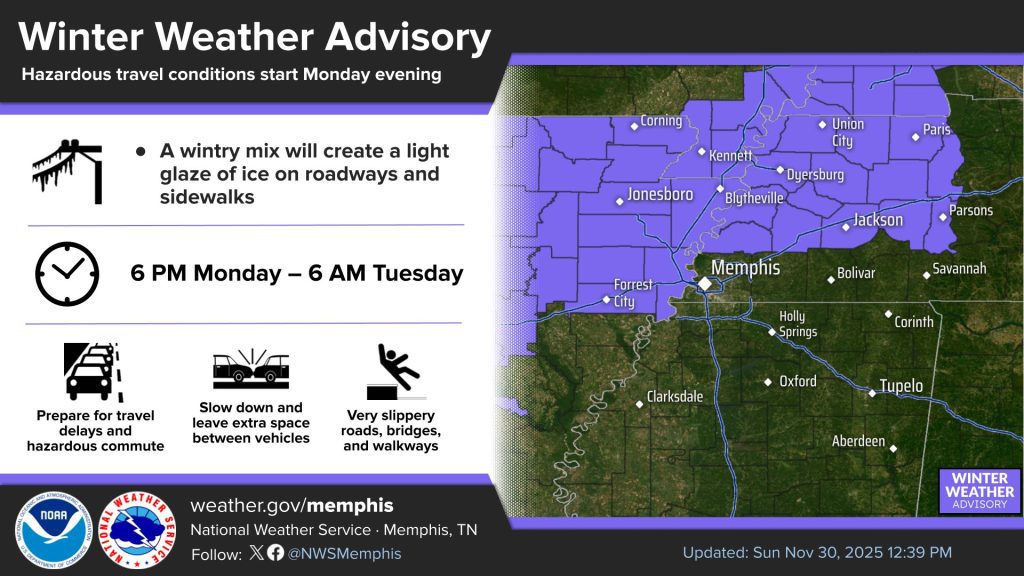
Due to the potential for minor accumulation of sleet or snow, the National Weather Service has issued a Winter Weather Advisory for Tipton and Crittenden Counties and points north for Monday night. Of course, if forecast conditions change (which is still possible 24-36 hours out), the advisory area could change.
Stay in touch with your favorite local weather sources for the most recent information leading up to and during the event in case the forecast changes. We’ll keep you updated on our social media platforms linked below throughout the event. And beware of stock weather apps on your phones, as they frequently trip and fall on their face in nuanced scenarios like this one!
Erik Proseus
MWN Meteorologist
—
Follow MWN on Facebook, Twitter/X, BlueSky, Threads and Instagram for the routine updates every day!
Visit MemphisWeather.net for the latest weather information and our MWN Forecast for Memphis and the Mid-South
Looking for a way to support us? Click here for one-time or recurring options! Thank you!







