


As summer approaches, weather discussion around the water cooler starts to shift from rain and spring storms to heat and humidity. But hurricane season, because of its significant impact especially to near-coastal areas, also becomes a topic of conversation.
Background on Atlantic hurricane season
Officially, the Atlantic hurricane season, what most people in the eastern part of the country are concerned with, begins June 1 and runs through November 30. (Not to neglect those living near other oceans, but there are also Eastern, Central and Western Pacific tropical seasons, and even an Indian Ocean season.)
Recently, the National Oceanic and Atmospheric Administration (NOAA)/National Weather Service released its annual forecast for the 2025 hurricane season. This official forecast provides some insight into the expected state of the ocean/atmosphere and what factors may result in above or below normal activity in the Atlantic and Caribbean. In addition, other research groups also issue seasonal tropical outlooks, most notably a team with decades of experience from Colorado State University.
An average Atlantic hurricane season generates 14 named storms, 7 hurricanes and 3 major hurricanes. A system is named when maximum sustained wind in a tropical low pressure system reaches 39 miles per hour, the threshold for a Tropical Storm. Hurricanes have sustained wind of at least 74 mph, while a Major Hurricane (category 3 or higher on a 5-point scale) contains wind of 111 mph or higher.
The 2025 Atlantic season outlook
NOAA’s official forecast for 2025 calls for a 60% chance of above normal activity in the Atlantic, noting multiple factors that could contribute to a more active than normal season. These include ENSO-neutral conditions, warmer than average ocean temperatures, the likelihood of weak wind shear, an active West African Monsoon (the genesis point for many Atlantic hurricanes). While sea surface temperatures are above average, providing extra fuel for storm development, they are not as warm as the past couple of hyperactive hurricane seasons. In addition, weaker trade wind across the Atlantic basin allows storms to develop without disruption.
| NOAA Forecast | CSU Forecast | Average Year | 2024 Season | |
| Named Storms | 13-19 | 17 | 14.4 | 18 |
| Hurricanes | 6-10 | 9 | 7.2 | 11 |
| Major Hurricanes | 3-5 | 4 | 3.2 | 5 |
The researchers at Colorado State University (CSU) are more specific in their forecast, but are in line with NOAA’s projections. CSU forecasts 17 named storms, 9 hurricanes, and 4 major hurricanes, with similar reasoning for busier than normal season.
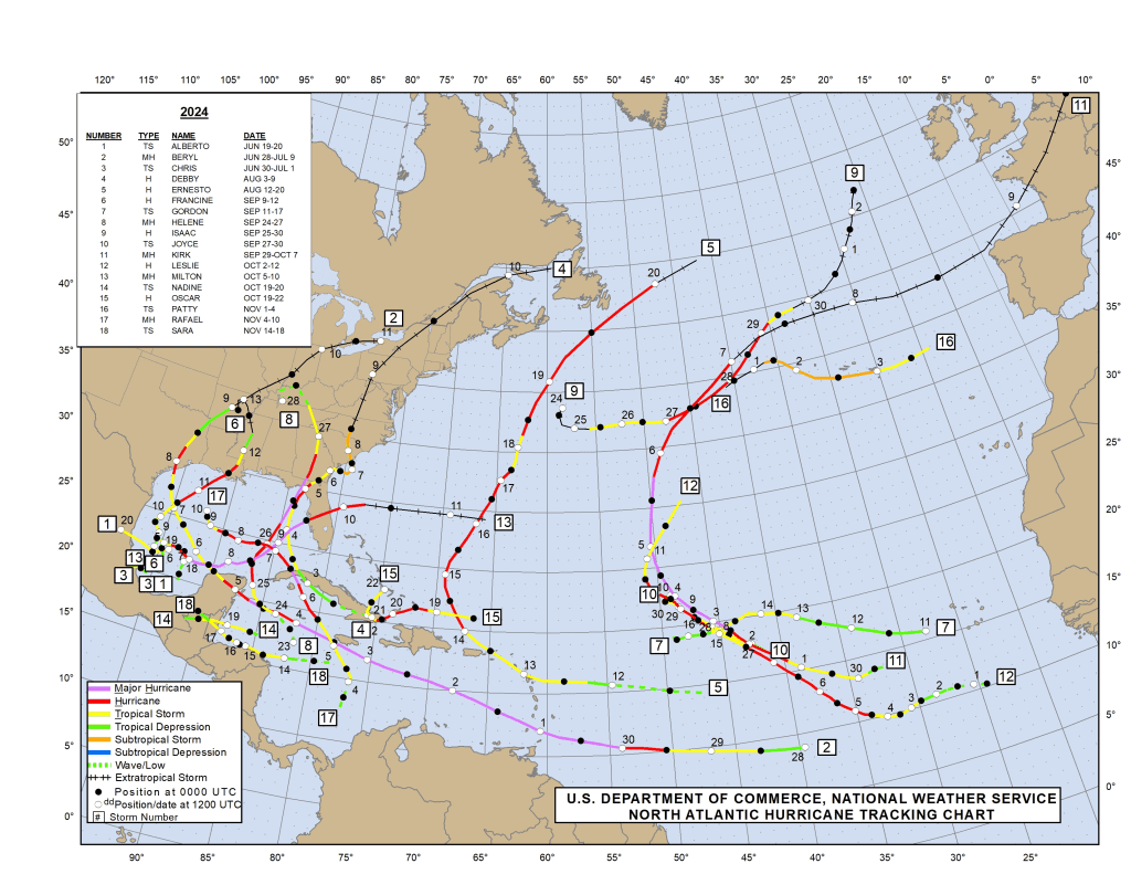
2024 was one of the most active, and costliest, hurricane seasons on record in the Atlantic, featuring 18 named storms, 11 hurricanes (five of which made landfall in the United States) and 5 major hurricanes. It was the first season since 2019 with multiple category 5 storms, which require sustained wind of at least 157 mph and, as a whole, resulted in approximately $130 billion in damage in the United States.
Potential impacts in the Mid-South
How does Atlantic hurricane season impact Memphis and the Mid-South? While certainly not located in a coastal area, landfalling tropical systems do occasionally impact the region. The most likely landfall region to watch for potential Mid-South impacts is the Gulf Coast, and more specifically Louisiana to the western Florida panhandle. The resulting track often takes those storms north from the Gulf.
Often, as storms gain latitude, they turn right (east) due to prevailing westerly wind aloft. Thus, landfalls further east in Florida typically remain well east of the Memphis area. Since 1950, 17 storms have passed within 60 miles of Memphis and only two of those didn’t make their final landfall along that stretch of land. Most were categorized as a tropical depression when they passed near Memphis, though a few were tropical or extratropical storms.
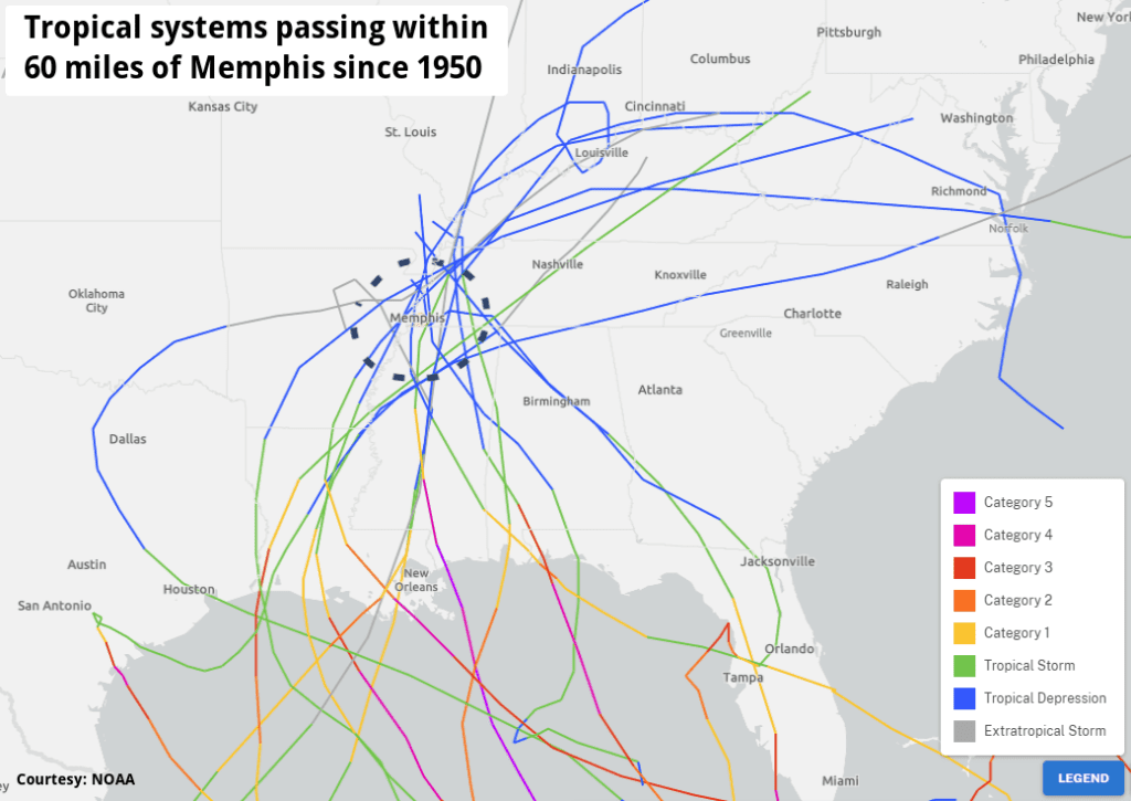
Impacts in the Mid-South from the remnants of tropical systems typically include heavy rain and breezy to strong wind. Last year, the remnants of Hurricane Francine, which made landfall southwest of New Orleans, stalled out over the Mid-South as an extratropical low pressure center in mid-September. Francine brought almost five inches of rain and wind gusts that reached 57 mph at Memphis International Airport. In October 2019, former Tropical Storm Olga quickly passed just east of Memphis and also dumped over four inches of rain.
And remember Hurricane Katrina, which devastated the city of New Orleans and the Mississippi and Alabama gulf coast in August 2005? Its remnants moved north through eastern Mississippi as a tropical storm, resulting in wind gusts over 50 mph in the metro. Memphians certainly need to be paying attention when a strong storm is heading towards the central Gulf Coast, as heavy rain and wind could occur locally a day or two later if the storm does not recurve to the east.
Looking ahead to summer
June also marks the start of “meteorological summer.” While astronomical summer doesn’t officially begin until the summer solstice (which occurs on June 20 at 9:41pm this year), meteorologists and climatologists break up the seasons into three-month periods for easier statistical comparisons, with summer being defined as June, July and August.
This spring started off warmer and drier than average in March, but quickly turned wet in April, continuing through May. The 2025 spring storm season will also long be remembered locally for its violent severe storms which featured two severe weather events in March before settings records for tornado warnings and tornado touchdowns in the Mid-South during the first week of April. Frequent storms also meant nearly a season’s worth of precipitation in April with continued rainy weather through May. The excessive precipitation also meant a cooler than average month to end meteorological spring.
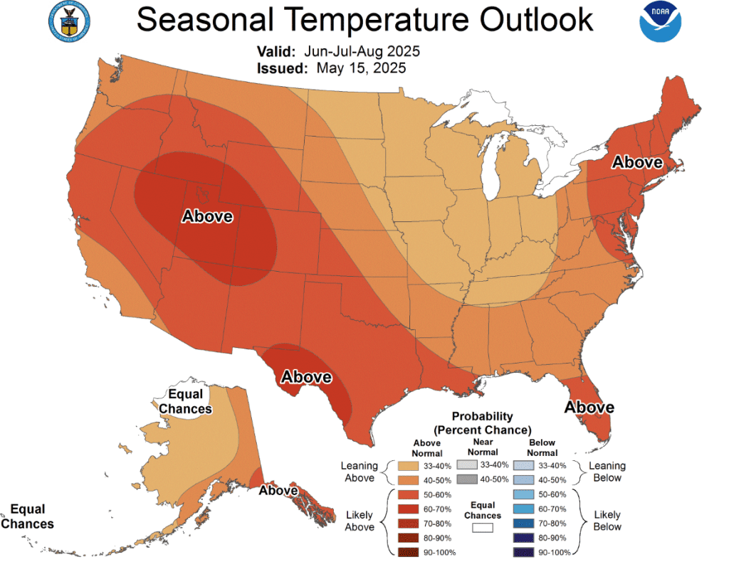
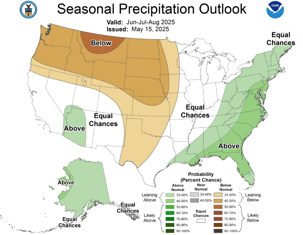
So what does summer hold? That seems like an obvious question to anyone who has lived through at least a couple of Mid-South summers – “hot and humid!” This year, the National Weather Service is predicting overall above average temperatures for the three-month period starting June 1 and equal chances of above and below average precipitation (or roughly near average).
During the “dog days” of summer, average high temperatures in Memphis are in the lower 90s and average morning lows are in the lower 70s. Rainfall typically totals just over 12 inches during the summer months, driven mainly by afternoon and evening thunderstorms that tend to provide a little relief from the summer heat, but also can make it even more humid.
Erik Proseus
MWN Meteorologist
—
Follow MWN on Facebook, Twitter/X, BlueSky, Threads and Instagram for the routine updates every day!
Visit MemphisWeather.net for the latest weather information and our MWN Forecast for Memphis and the Mid-South
Looking for a way to support us? Click here for one-time or recurring options! Thank you!







